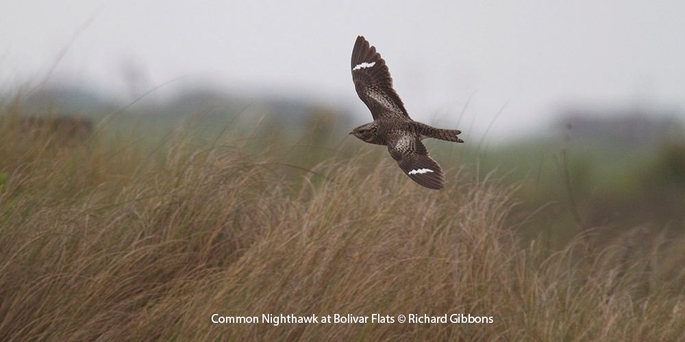
Houston Audubon comments on the Coastal Texas Study and an additional statement from a group of 15 conservation organizations.
USACE, Galveston District
Attention: Ms. Jennifer Morgan
Environmental Compliance Branch, RPEC
Post Office Box 1229
Galveston, Texas 77553-1229
Re: Houston Audubon Society comments on DRAFT COASTAL TEXAS PROTECTION AND RESTORATION FEASIBILITY STUDY - DRAFT INTEGRATED FEASIBILITY REPORT - ENVIRONMENTAL IMPACT STATEMENT (Coastal Texas Study DIFR-EIS)
Houston Audubon Society (HAS) is a 501(c)(3) organization which has concerns about the Coastal Texas Study DIFR-EIS both from the standpoint of how it may affect the environment and how it may affect the bird sanctuaries owned and protected by HAS. Since its formation in 1969 HAS, like other Southeast Texas residents, has experienced the devastating effects of many hurricanes and other severe storms. Future storms could be even more catastrophic. While we believe that actions can be taken to protect our coast, we strongly urge taking the time to do it right. The massive expense and possible adverse consequences, some of which are not fully addressed in this Coastal Texas Study DIFR-EIS, require better evaluation of possible environmental degradation and of the best ways to enhance natural buffers to storms. The possible harm to Galveston Bay due to changes in salinity and amount and velocity and flow of water and sediment buildup on Bolivar roads is a concern. Loss of habitat for birds and other wildlife on beaches, wetlands, and riparian areas is minimized in the report. Specific comments are as follows:
1. Sanctuaries omitted from plan. HAS is one of the largest private landowners along the Upper Texas Coast. It has landholdings that are protected as sanctuaries for birds and wildlife on Galveston Island (Dos Vacas Muertas), on Bolivar Peninsula (Horseshoe Marsh, Bolivar Flats, Mundy Marsh) and High Island (Boy Scout Woods, Smith Oaks, Gast Woods, Eubanks Woods). See attached maps (Ex. A). HAS properties are not listed as protected lands in the Coastal Texas Study DIFR-EIS. These are world renowned sanctuaries visited by tens of thousands of visitors every year, which contribute significantly to more diversified and resilient regional and local economies. It is also important to note that much of this habitat was purchased with federal funds with the express legal requirement that they be managed into perpetuity for the protection of habitat for birds and other wildlife.
2. Lack of notification. Despite being a large landowner and participating in several stakeholder events with the Corps over the years regarding this project, HAS was not notified of the October 26, 2018 release of the Coastal Texas Study DIFR-EIS. This is one indication that the Corps’ public participation process was not adequate.
3. No notice to landowners. It does not appear that landowners who may be affected by construction and/or eminent domain during the proposed project have been identified or notified about the release of the Coastal Texas Study DIFR-EIS. HAS is such a landowner and was not notified prior to or at the time of the release. Better public notification and participation is important for any plan to be properly vetted.
4. High Island importance and concerns of habitat loss. High Island is an elevated landform created by the rise of a subterranean salt dome. Its location at the Texas coastline on Bolivar Peninsula makes it unique among Texas’s salt domes. This coastal position also creates its importance to the migratory bird population. The mature oak mottes in High Island on the elevated land are a critical stopover for spring migrating birds. After an 18-hour journey across or around the Gulf of Mexico, migrating birds see this “island” of trees surrounded by marshes and prairies and alight into the trees to rest and to feed on insects and seeds before continuing their northward journey to breeding grounds in the US and Canada. Without this critical habitat at the shoreline many of these birds would die before reaching the woods of East Texas miles further north. We are very concerned with the potential for habitat loss as a result of changes to hydrology and erosion during storm events. The dike appears to be using the salt dome as the barrier in conjunction with the levee. These rare and critically important habitats should not be put in harm’s way and the onus is on the GLO and USACE to show definitively that this proposed structure will not cause loss of habitat.
5. Concerns about HAS sanctuaries and birds. Many species of birds, called Neotropical migrants, nest in North America and spend the winter in Central and South America. Twice yearly these birds migrate the long distances between wintering grounds and nesting locations. Each spring millions of birds that wintered in Central and South America are driven north by the urge to establish breeding territories and select mates.
During the spring migration period from early March to mid-May conditions occasionally exist where strong turbulent north winds and rain trigger a phenomenon called a “fallout”. Thousands of extremely tired migratory birds are forced to seek shelter and food as soon as they reach the coast. At these times, good-quality habitat along the coast, like the HAS sanctuaries, is vitally important to the survival of tens of thousands of birds.
Boy Scout Woods Bird Sanctuary consists of 60 acres of woods, coastal prairie and wetlands, and is located one mile from the Gulf of Mexico on High Island. Smith Oaks Sanctuary contains oak mottes with live oaks more than 100 years old, ponds, wetlands and coastal prairie. The U-shaped island in the middle of Claybottom Pond at Smith Oaks known as the Rookery, has become a favored roosting and nesting place for thousands of waterbirds. In the spring and summer, herons, egrets, cormorants, and spoonbills build their nests and raise their chicks on the predator-free island. Additional rookery islands were recently constructed as part of national efforts to address harm caused to species most impacted by the Deepwater Horizon oil spill.
Bolivar Flats is a unique area combining salt marsh, mud flats and beach, each habitat quite different from the other. Bolivar Flats is a Globally Important Bird Area, the highest designation, and is an International site in the Western Hemisphere Shorebird Reserve Network. HAS’s sanctuary includes property from the beach and the flats inland to the highway. It is not clear where the levee is proposed to be constructed relative to our property. Perhaps more importantly, when the surge hits the levee and is repelled, significant turbulence and erosion would be likely. This issue is not adequately addressed in the report.
Horseshoe Marsh that lies north of U.S. 87 and extends from Galveston Bay inland at the western tip of the Peninsula. Here the concern is more about loss of land from either levee or gate construction. We strenuously object to the taking of this property without a serious evaluation of the extent of the damage to our property. What has been done so far has not included concern for HAS properties or the birds that depend on them.
6. Flow around dike causing potential damage to High Island Sanctuaries and town. The sanctuaries at High Island are vital to the birds migrating north from Central and South America. Regarding High Island and its sanctuaries, the major concern is that the levee system appears to end and proceed north at SH 124. The bulk of the sanctuaries owned by HAS are east of 124 on the edge as well as the top of the salt dome. We believe that the surge will be increased at the end of the levee thereby sending water around and up atop the High Island salt dome, thereby flooding and potentially destroying some of the best stopover habitat and bird watching areas of the United States. The town of High Island and its residents previously protected due to the elevation will be placed in harm’s way. These properties will be negatively impacted as a result of the federal action being taken.
7. Impact on Threatened and Endangered Species. The project as proposed, will impact at least two endangered species, and several threatened species. However, because details and analyses were omitted from this report, it is impossible to understand impact. The endangered species are the Piping Plover and the Kemp’s Ridley Sea Turtle. Piping Plovers are migratory birds that spend the majority of the year foraging and resting on the Gulf Coast beaches and mudflats. If the levee on either Bolivar or Galveston Island is to the beach side of the homes facing the Gulf, there is high probability of violation of the federal Endangered Species Act. Kemp’s Ridley Sea Turtles as well as other sea turtles nest on Bolivar Peninsula and Galveston Island beaches. They depend on minimally disturbed beach areas that provide protection to survive. If the levee is to the beach side of the Gulf-oriented homes, this is a major issue. The point here is that the Coastal Texas Study DIFR-EIS has not done sufficient work to understand if there is an impact, or potentially a legal issue, with this proposal. It is unsatisfactory and unscientific to go forward without this information.
HAS and American Bird Conservancy have breeding bird and wintering bird data that illustrates the importance of storm and flood events in a coastal ecosystem. Storm effects on coastal habitats are an inherent part of this dynamic ecosystem and are necessary to maintain optimal habitat for birds and other coastal wildlife over time. These events scour over-vegetated habitat to provide open sandy areas for declining beach-nesting species such as Least Terns, Wilson’s Plovers, Snowy Plovers, and Black Skimmers. Storms can push sediment around causing sand accretion which elevates habitat and decreases the risk of nests and chicks from being washed out from future high tide events. The accreting Gulf beach at Bolivar Flats Shorebird Sanctuary resulted in a significant increase of Least Tern breeding pairs between the 2016 and 2017 nesting season, with 54 breeding pairs in 2016 and 137 breeding pairs in 2017. Suitable nesting habitat is in decline and so are coastal breeding birds. While birds will move from over-vegetated less favorable areas to less vegetated more favorable habitats, it is critical to ensure the ongoing dynamic functionality of coastal areas as a holistic means to responsibly managing coastal resources with wildlife and human uses in mind. The probable refractive energy that would be produced during a storm event could potentially destroy the balance of forces that has produced this globally important wildlife sanctuary.
8. Impact to nature tourism. HAS is primarily interested in protection of ecosystem processes, habitat and direct impacts to avian populations across the Texas coastal, bay and estuarine environments. An equally important human-interest consideration, however, is how this coastal barrier system affects the economics associated with nature tourism. We believe the Coastal Texas Study DIFR-EIS does not adequately identify the potential effects to nature tourism and specifically birdwatching activities as they are intrinsically linked to the status of the natural environment. Coastal ecotourism across the four counties that border the Galveston Bay system; Chambers, Galveston, Brazoria and Harris, will be impacted by changes within the Bay and along the barrier island system.
According to the 2016 National Survey of Fishing, Hunting and Wildlife-Associated Recreation published by the US Department of the Interior, US Fish and Wildlife Service and US Department of Commerce, there has been a marked increase in both the number of people involved in wildlife watching, and the money they spend on their activities since 2011. In 2016, 86 million US residents 16 years old and older observed, fed and/or photographed birds and other wildlife. 45.1 million specifically observed birds around the home and on trips. The national total for trip related and equipment expenditures associated with wildlife watching was $66.7 billion. This was a 20% increase in the number of people participating in wildlife watching activities between 2011 and 2016 and a corresponding 90% increase in equipment expenditures. Birdwatching is an economic driver for nature tourism and the upper Texas coast is a major destination for regional, national and international birders.
More than 10,000 tourists visit Houston Audubon’s High Island sanctuaries every spring to witness the wonder of spring migration. Approximately 50% of these visitors are from Houston, 25% are from other areas of Texas and the remaining 25% are from the other US states and 20 countries, most of whom travel through Houston.
A survey of the web-based, citizen science database eBird revealed that there are 70 hotspots along the footprint of the proposed coastal barrier from north of High Island to the west end of Galveston Island. The current year’s data through 11 months of 2018 revealed more than 8300 trips with an average species list of 113 across these 70 hotspots. The 10-year data revealed nearly 43,500 trips with each hotspot averaging 187 species of birds. A single species query using “Great-tailed Grackle” for the first 11 months of 2018 yielded 465 unique trip accounts across this same region, emphasizing the popularity of birdwatching in the areas that will be directly impacted by any physical alterations to the environment.
Of bigger concern to HAS would be the more indirect impacts associated with ecosystem disruptions to the Galveston Bay complex. Using the examples of unintended consequences associated with the coastal protection measures installed by the Netherlands, we are gravely concerned that the potential alteration of tidal flow, nutrient flushing, sedimentation patterns, larval migrations and ecological processes will lead to major changes within the greater Galveston Bay complex that this Texas Coastal Study DIFR-EIS has not sufficiently addressed. The effects of ecosystem and habitat disruptions will have an economic impact to nature tourism.
9. Residual Risk. In addition to the residual risk of Galveston’s Bay storage capacity for Alternative A, there are several other risks associated with this alternative not addressed by the report. With an extreme rain event, such as Harvey, the storage capacity of Galveston Bay will be tested and the ability for the water to drain into the Gulf is reduced because there are fewer places for the water to exit. This retention of flood waters will extend the time the area is flooded.
Another risk is the damage incurred at the edges of the barriers as the surge moves around the barrier. There could be environmental damage through erosion and property damage as the currents rushing around the edges could be magnified.
Finally, as with a rain event the return of surge waters that penetrated behind the barriers by going around the edges will be trapped behind the barriers and flow into Galveston Bay, again extending the flooding period.
In summary, the lack of complete information causes HAS to request a supplemental Draft Environmental Impact Statement. It has been stated that the current draft is only a 10% design. That is not enough detail to make valid assessments of the impacts of the project to people, property and the environment. The current draft did not even take into consideration and assess the impacts to HAS protected properties. HAS also requests an extension of time to comment. The public has not been adequately informed as previously stated and the time frame included numerous holidays.
Sincerely,
Timothy H. White
Board President
Helen E. Drummond
Executive Director
Exhibit A
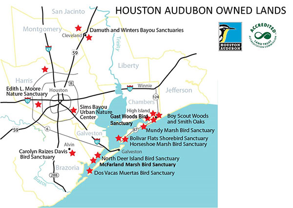
Houston Audubon Owned Lands
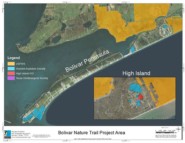
Bolivar Nature Trail Project Area